Eine Wanderung machen
Die besten Wanderungen in der Nähe von Seattle
Der Herbst ist eine der besten Jahreszeiten für Wanderungen im Nordwesten.
Die Wanderwege der Region bieten ein spektakuläres Schauspiel mit leuchtendem Herbstlaub, das unsere charakteristischen immergrünen Bäume ergänzt. Gleichzeitig sorgen die kühleren Temperaturen dafür, dass Sie bei Ihrer Wanderung nicht überhitzt werden.
Wanderungen in oder um Seattle für Anfänger:
Für den perfekten Spaziergang im Frühherbst besuchen Sie den Alki Beach Park, einem langen Strandabschnitt, der sich von Alki Point bis zum Duwamish Head (einem Wahrzeichen mit Blick auf die Elliott Bay) erstreckt. Auf der 2,5 Meilen langen Wanderung genießen Sie einen Panoramablick auf den Puget Sound, die Olympic Mountains und die Skyline der Innenstadt von Seattle. Starten Sie am Jack Block Park, umrunden Sie dann den Point am Anchor Park und machen Sie sich auf den Weg zum Leuchtturm von Alki Point.
Länge: 2,5 Meilen
Entfernung von Seattle Southside: 14 Meilen
Coal Creek Pfad
Östlich von Seattle Southside bietet der Cougar Mountain Park mehr als 35 gut gepflegte Wanderwege, die sich durch Wälder, Feuchtgebiete, Klippen und Höhlen schlängeln. Der Coal Creek Trail ist ein beliebter Waldwanderweg mit historischen Artefakten, Wasserfällen und Holzbrücken. Folgen Sie dem Weg hinunter in eine tiefe Schlucht, vorbei an alten Minenschächten, Eisenbahnschwellen und anderen Überresten des Kohlebergbaus aus dem späten 19. Jahrhundert. Der Höhenunterschied ist nicht allzu groß, daher ist dieser Weg eine gute Wahl, wenn Sie sich nicht zu sehr anstrengen möchten.
Länge: 6 Meilen Hin- und Rückweg
Entfernung von Seattle Southside: 13,5 Meilen
Grand Ridge Park
Der Grand Ridge Park verfügt über 7 Meilen malerischer Wanderwege, die sich durch Wälder aus westamerikanischer Rotzeder schlängeln. Dieses 1.300 Hektar große Wildnisgebiet liegt nördlich von Issaquah und Lake Sammamish und steht Wanderern, Mountainbikern und Reitern offen. Ein Highlight des Wanderwegs ist eine wunderschöne, 40 Fuß lange, handgefertigte Brücke, die den Canyon Creek überspannt.
Länge: 14 Meilen
Höhenlage: 1.100 Fuß
Entfernung von Seattle Southside: 25 Meilen
Wanderungen mit Aussicht nicht weit von Seattle
Granitbergweg
Der Granite Mountain Trail ist der meistbegangene Gipfelweg im Snoqualmie Pass-Korridor. Obwohl er die Waden ganz schön strapaziert, lohnt sich der Aufstieg über 3.800 Fuß in 4,3 Meilen aufgrund der 360-Grad-Aussicht auf den Mt. Rainier und den Snoqualmie Pass auf jeden Fall.
Länge: 8 Meilen
Höhenlage: 3.800 Fuß
Entfernung von Seattle Southside: 52 Meilen
Pratt Lake Trail
Der Pratt Lake in der Nähe des Snoqualmie Passes ist ideal für diese Übergangszeit, und der Pratt Lake Trail eignet sich hervorragend zum Angeln, Klettern und für andere Wanderungen. Die Rundwanderung ist 8 Meilen lang und führt durch Wälder und gelegentlich über felsige Hänge mit Blick auf die Berge, Wildblumenwiesen und alte Wälder.
Länge: 8 Meilen
Höhenlage: 2.300 Fuß
Entfernung von Seattle Southside: 52 Meilen
Wallace Falls
Die Wallace Falls liegen auf der Westseite der Cascade Mountains und bestehen aus einer atemberaubenden Reihe von neun Wasserfällen, von denen der höchste 265 Fuß tief ist. Die Rundwanderung erstreckt sich über 5,5 Meilen und führt Abenteurer durch alte Nadelwälder, entlang schnell fließender Flüsse, mit malerischen Ausblicken auf die Berge und einer reichen Tierwelt entlang des Weges. Obwohl die Wasserfälle das ganze Jahr über schön sind, empfehlen Einheimische einen Besuch an einem regnerischen Tag – jeder Regentropfen fließt in den Wallace River und verstärkt die Kraft und Dramatik der herabstürzenden Wasserfälle.
Länge: 5,5 Meilen
Höhenunterschied: 1.200 Fuß
Entfernung von Seattle Southside: 55 Meilen
Mount Si
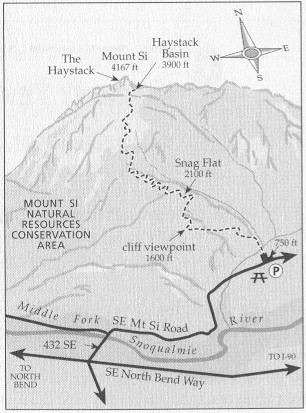
Der Mount Si ist eine anspruchsvolle und beliebte Wanderroute im Mount Si Natural Resources Conservation Area in der Nähe von North Bend, Washington. Der Weg ist insgesamt etwa 13 km lang und hat einen Höhenunterschied von etwa 960 m. Die Route beginnt in einem dichten Nadelwald und steigt über gut gepflegte Serpentinen stetig an. Nach etwa 5,6 km werden Wanderer mit einem atemberaubenden Ausblick von einem felsigen Hang belohnt, von dem aus man an klaren Tagen sogar den Mount Rainier sehen kann. Der letzte Abschnitt führt zu einem Plateau unterhalb des Gipfels; erfahrene Wanderer können den „Haystack” erklimmen, um einen Panoramablick zu genießen.
Höhenunterschied: 3.150 Fuß
Entfernung von Seattle Southside: 40 Meilen
Für Abenteuerlustige ist der Haystack am Mt. Si eine kurze Kletterpartie zum Gipfel und gilt als moderater Aufstieg der Klasse 2/3.
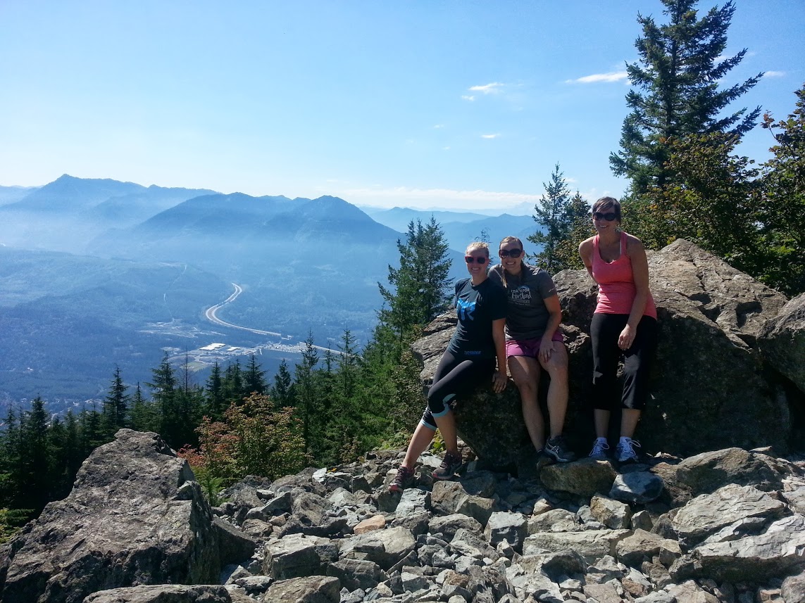
Wir saßen in der Sonne und entspannten uns ein wenig, genossen die weite Aussicht, die Tierwelt und aßen ein paar Snacks. Nachdem wir für ein paar Fotos posiert hatten, um unsere Leistung zu dokumentieren, machten wir uns auf den Rückweg und sprachen den Wanderern auf dem Weg zum Gipfel unsere eigene Ermutigung aus.
Da wir uns auf dem Aufstieg so viel Appetit geholt hatten, kehrten wir in der North Bend Bar und Grill für Burger. Dies ist ein gutes altes Restaurant mit tollem Essen und einer gemütlichen Atmosphäre. Es gibt sogar einen Kamin mit einer großen Couch, auf der man es sich in den kälteren Monaten gemütlich machen kann.
Länge: 4 Meilen
Höhenlage: 3.700 Fuß
Entfernung für Seattle Southside: 40 Meilen
Schnappen Sie sich Ihre Wanderschuhe, Wasser und eventuell eine Regenjacke und gehen Sie nach draußen, bevor die Sonne für den Winter verschwindet.
Sie könnten auch interessiert sein an...

Wo kann man in Seattle Southside trainieren?
Laufen, Radfahren, Springen, Dehnen ... es gibt unzählige Möglichkeiten, sich in Seattle Southside ins Schwitzen zu bringen.

Stadtradeln: Das Beste der Southside von Seattle
Treten Sie in die Pedale...Pedale! Radfahren ist eine umweltfreundlichere und gesündere Art, sich in der Stadt fortzubewegen.